 |
| 1519, St. Helena, Atlas Nautique du Monde, Biblioteheque National de France |
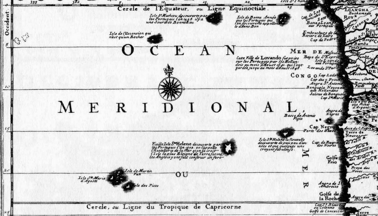
The genesis of this post was the page in the Maps and Views section of Barry Weaver’s St Helena Virtual Library and Archive illustrated by a part of Jansson’s 1646 map “Mar di Æthiopia Vulgo Oceanus Æthiopicus which describes the appearance, on early maps, of the mythical islands of New St. Helena and St. Matthew. It can be accessed here: http://www.bweaver.nom.sh/maps/jansson.htm
As he suggests: “the mislocation of islands was inevitable given the large navigational errors common in the sixteenth and seventeenth centuries, but once added to sea charts such islands proved extremely resilient, even in spite of a lack of any further evidence to support their existence.”

1547,Vallard Atlas, St. Matthew and St. Helena, South Orientation
Click on images to enlarge
Click on images to enlarge

1554, Gastaldi, St. Matthew and St. Helena, South Orientation

1570, Ortelius, St. Matthew

1596, Linschoten, St. Matthew and St. Helena
In 1656 Peter Mundy refers to St Matthew Island when writing about Ascension:
Soe now againe concerning the Ascention birds allsoe, thatt can neither fly nor swymme. The iland beeing aboutt 300 leagues from the coast of Guinnea and 160 leagues from the iland of St Matheo, the nearest land to it, the question is, how they shold bee generated, whither created there from the beginning, or thatt the earth produceth them of its owne accord, as mice, serpentts, flies, wormes, etts, insects, or whither the nature of the earth and climate have alltred the shape and nature of some other foule into this, I leave it to the learned to dispute of.
By 1634, in addition to St. Matthew, a second St. Helena started to appear on Maps and Charts.

1634, Guerard, Carte Universelle Hydrographique, Biblioteque National de France

1664, Du Val, I Ste Helene la nouvelle

1689, Coronelli
Though admitting that the New Isle of St Helena was thought by many to be legendary, St. Matthew is described as having a small lake of good fresh water and that it was discovered in 1526.

1706, Schenck

1717, Nicholas de Fer
1722, Nicholas de Fer
De Fer repeats the same information about St. Matthew as the 1689 Coronelli map
On his second voyage Cook sailed on “Resolution” from St. Helena on the 21st May 1775. On the 31st May he left Ascension and “steered to the northward with a fine gale at S. E. by E.” “I had a great desire to visit the island of St. Matthew, to settle its situation; but as I found the wind would not let me fetch it, I steered for the island of Fernando de Noronha, on the coast of Brazil in order to determine its longitude, as I could not find this had yet been done. Carrying on board Kendall’s KI chronometer "Resolution" was the first survey ship to carry such an instrument and had St Matthew existed would have been charted with some accuracy.
Purdy's 1814 "Tables of the observed positions of the principal points and places on the coasts of the Atlantic, Ethiopic and Indian Oceans" casts doubt on the existence of St. Matthew:
"We are told, by several historic geographers, that St. Matthew is an island discovered by the Portuguese, in the year 1516, by whom it was afterwards planted; and that vessels frequently stop here some days to take in refreshments. Guthrie says (Edition of 1783) the Portuguese " planted and kept possession of it for some time; but afterwards deserted it. This island now remains uninhabited, having little to invite other nations to settle there, except a small lake of fresh water."
"We think it not improbable that this island, like the Land of Bus, in the Northern Ocean, may have entirely disappeared. Archihald Dalzel, Governor of Cape Coast Castle, sought for it, without success, in 1799 and 1802, and it appears almost certain, from his routes, between 1 and 2 degrees South, longitude, 3 to 10° W. that it does not exist within this space. "Mr. Dalzel has made many enquiries among the Portuguese about this island, without meeting with any person who pretended to have seen it, except one, who gave him a rough draught of it, which was laughed at by the other Brasilians, who said he must have been deceived by a cloud."
It did, however, still appear on the 1828 German map below.

5 comments:
I have a framed text that briefly describes St Matthew. Nick Thorpe of St Helena asked me what document it came from. I couldn't answer, though I can say it's on page 434 of a book called A New, Royal and Authentic (rest of title obscured)
The brief text reads: It is a defart, though there is a fine rivulet of frefh water that runs through it. Garcias de Loaifa, a gentleman of Bifcay, in Spain, who commanded the fleet which the empoeror Charles V. caufed to be fitted out at the Groyne, to go and conquer the Molucca Iflands, having landed at the ifland of St. Matthew, found it uncultivated but full of large orange trees. He found alfo fome poultry there; and on the barks of trees there were infcriptions in the Portuguefe tongue, which proved that fome of that nation had been there."
Do you know anything about this? Aside from the use of f for s, it doesn't look old.
Simon Pipe, UK
Simon,
I think the full title is: A new, royal, and authentic system of universal geography: antient and modern: ... containing a genuine history and description of the whole world, ... By the Rev. Thomas Bankes, ... Edward Warren Blake, Esq. Alexander Cook, Esq. and Thomas Lloyd. Embellished with near two hundred beautiful engravings
If you Google A new, royal and authentic system of universal geography+La trobe journal there is an article describing the book. I can’t find a download of the book but it looks like a collection of references and collated information from other sources.
The text you have is likely to be from this book but the original source is from the Portuguese.
Google “Garcia de loaisa”1525 to find references to his expedition
http://books.google.co.uk/books?id=HAdbAAAAQAAJ&pg=PA165&dq=%22garcia+de+loaisa%22+1525&hl=en&ei=fqOuToe7J8TItAax_qT2Cw&sa=X&oi=book_result&ct=result&resnum=2&ved=0CDsQ6AEwAQ#v=onepage&q=%22garcia%20de%20loaisa%22%201525&f=false
Also Google: http://www.columbia.edu/itc/mealac/pritchett/00generallinks/kerr/vol02chap01sect03.html and scroll down to the date 1525 where the text is similar to yours.
What I find surprising is that the St Matthew in these accounts was supposedly found on a voyage to Brazil. The island to which I refer in my blog isn’t on the way to Brazil, except by the scenic route, so I wonder if it’s the same one. The route to the Far East in 1525 would have been across the Atlantic, then south to pick up the trade winds and it was usually only homeward bound ships that sailed near St Helena, and who thus may have seen St Matthew. A mystery.
If you can’t follow the links or want more information email me directly at pandjcg@o2.co.uk
There are more St. Helena pictures on our flickr site at:
http://www.flickr.com/photos/30593522@N05/sets/72157624078044217/
We had real fun following The Great Wood Wall, visit soon before it falls down completely.
Kind Regards
John Grimshaw Manchester
The inclusion of the precise word 'Nova' almost certainly suggests that 'S. Helena Nova' was nothing other than the real St Helena displaced into the wrong longitude, and that the alternative name arose due to a misreading or concatenation of an early inscription that had somehow incorporated the name of João da Nova, the discoverer of St Helena, into its wording. However, later cartographers, notably Pierre Du Val for his map "L'Afrique" of 1664, and Guillaume Sanson for his "Afrique" of 1668, began to lose sight of the all-important allusion to Da Nova by miscontruing 'Nova' as 'new' and labelling the island 'Ste. Helene la Nouvelle' (New St Helena) - a most unlikely name for a newly discovered island.
In fact the existence of the island had effectively been disproved as early as the 1680s, several ships of the Dutch East India Company having sought it in vain, notably the "Leonen" in 1660, and the yacht "Maria" in 1678, the latter having spent two fruitless weeks in pursuit of an island which, it is said, the Dutch were anxious to colonise as a complement to their Table Bay anchorage.
still a big possibility.
"The expedition set sail from Corunna on July 24, 1525. It consisted of seven ships, Santa María de la Victoria, Sancti Spiritus, Anunciada, San Gabriel, Santa María del Parral and San Lesmes and a patache, Santiago. De Loaísa was named captain along with Juan Sebastián Elcano, who had reached the Spice Islands in 1521 during the Magellan expedition.
The fleet headed southwest to the Canary Islands and then south along the African coastline.[3] In November 1525 de Loaísa moved west across the Atlantic to Brazil, reaching the Patagonian shore in January 1526"
and this landmass looks pretty compelling for google maps
https://goo.gl/maps/KxJDEaSZDkza3Sdu5
Post a Comment